Sunday, October 31, 2010

Game Day


Penn State does love their football. And Halloween. This weekend was the perfect storm: Saturday night game, against Michigan, on Halloween. Even by Friday afternoon it was difficult to drive out on the strip and hard to walk downtown. Amazing how much shopping was going on with the football crowd - you'd think they didn't have shopping at home. But I'm sure it was partly nostalgia - to shop where you used to shop as a student, or eat where you used to eat, or to see what's new in town since you left.

Friday night was quite a treat as the students put on a wonderful show in the streets with their costumes. Costuming here is very big - some very creative. I wish my camera worked better in low light so I could have gotten some pictures. We had a guy in a shark costume wearing a Joe Patterno mask, a very nice home-made dinosaur outfit, a Captain America unitard, it was endless as folks just swarmed downtown seeing and being seen. Oh, and drinking. There was some disappointment here this year when Penn State fell from number 1 to number 3 party school in the nation.

Ann's co-worker Renee and her husband Dave have been going to the games for years, and invited us to tailgate with them at their camper in the lot across from the stadium. So at 4:30 we jumped on our bikes and rode the 2 miles across campus to the stadium to their encampment. Traffic by that point was surprisingly minimal. Everyone who was going to find parking had already found parking somewhere long before then. Given the heavy pedestrian traffic across campus, many must have parked far, far away. It seemed barely 50 degrees out, but the line for ice cream at the Creamery snaked around the block. A few blocks from the stadium, all roads were closed to cars and we were joined in the street by the happy inbound crowd - a few weaving a bit. For them the drinking had started long before - probably the night before.

On game day, State College is the third largest city in Pennsylvania -108,000 fill the stadium in a town of 30,000. It is quite a site. Many folks have had their tailgating spot for years, and know their tailgating neighbors - although that is changing as ticket prices rise and more are sold to businesses to be distributed as perks to a different employee each game. Renee and Dave put on a wonderful spread, and even provided outdoor satellite TV so all could watch the pre-game. Family and friends came and went, visited and ate. The kids played in the motor home. The beef stew in the crock pot inside was heaven. We enjoyed the socializing and soaking up the pre-game atmosphere. A few brave souls from Michigan across the way in their full Maize and Blue regalia received only a little good natured ribbing and seemed to know the Penn Staters nearby well. I guess that's the Big Ten for you - rivalry and camaraderie. If you didn't go to one Big Ten school and your spouse another, it's likely your kid does.

As game time approached and the temperatures dropped, the parkas and blankets came out, the stadium lights came on, and we bid farwell, stuffed our hot dish in the pannier, and rode our bikes west into the sunset against an ever thickening stream of humanity clad in Blue and White headed for the Game.

Friday, October 15, 2010

5-Crossing the Appalachians on the Great Allegheny Passage: Cumberland to C&O Lock 73


Sleeping in the car the last night was a bit odd. The National Park has a free overnight parking area - perfect for Mr. Cheap. Unfortunately, it's under the I-68 overpass. Not that I'm complaining - it's free, and it really is a good use for the space. And I guess the sound of the semi's overhead did kinda sound like surf if you used some imagination. Though I didn't expect to be able to feel them pass over through the suspension of my car 50 feet below. Actually I did sleep well.

Right next door to the overpass is the historic train station, now used by the Western Maryland Scenic Railway upstairs and the Park Service downstairs for their canal interpretive center. At 7 am, though, what I really was interested in was a restroom. No luck - all the public restrooms were locked until opening at 9. I wasn't going to make it to 9. My other overnights had been rural with pit toilets - they're open when you need them. So I went searching for a breakfast joint. The one I wanted to try on the waterfront was closed for the season, so after walking downtown for a while I ended up at a McDonalds. Not what I had in mind, and  insipid as expected, but I needed inputs and outputs. And wouldn't you know it, on the way back to the car on a side street I found the place I was looking for originally. What was closed on the waterfront was their summer tourist stand. The Queen City Creamery and Deli has flower boxes overflowing its sign, a deli, an attractive diner style counter, and homemade breakfasts - but I was full of McBurrito. So now I know I need to come back with Ann, the breakfast queen herself.

Rested and ready, I jumped on the bike and headed from the mile184 marker down the towpath. The C&O Canal path has a completely different character than the Great Allegheny Passage. To be expected since it was not a railroad - it only had to be wide enough for a mule, the speeds were much lower, and the cargo carriers only 90 feet long. It is also completely flat, falling only 700 feet in 184 miles. And it is accompanied by a pond, or a swamp, or a grassy ditch all the way.
The surface is not pristine limestone dust like the Passage, but more a high quality two track, with evidence of occasional puddles and small ruts during wet spells. You won't need a mountain bike, but wider tires, and maybe some tread, might be good. The path itself is nicely shaded and covered by trees, but the surrounding plain is prime farmland and industrial land, so you see a lot more civilization. As well as the Potomac River which the canal followed and borrowed water from.


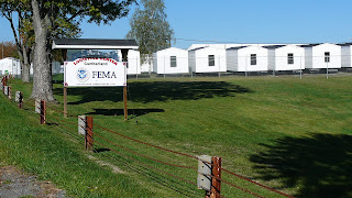
Look at this FEMA trailer storage facility I found (Next to a power plant, downstream a bit from a prison, across from a water treatment facility. You get the idea. Though from the map it looks to get wilder again before Hancock and Hagerstown). I never thought about where they kept those things, waiting for the next disaster. The cool thing about this trail is that in such a developed area it exists at all, and in fact goes unbroken all the way to Washington D.C. ending in Georgetown on the waterfront. 

So I was looking for more history than scenery on the towpath. And the aqueduct carrying the canal over a tributary of the Potomac and the locks were worth the 7 mile ride to them. One lock was reconstructed so you could see how it worked, as was the lock keeper's house. The technology of the canals preceded the railways, and was incredible in its own right. This one was originally conceived by George Washington and partners, but not built by others until the after the success of the Erie Canal. The interpretive center at the Park headquarters gives a nice overview of the technologies and people of the canal. It's well worth a stop. And they do have nice restrooms when they're open.

The towpath has nice campsites regularly along the path on the Potomac, but I decidedly prefer the wilds and mountains of the Passage.


My history mission complete, I headed back to Cumberland for a final meal before leaving for home. Success again - Ristorante Ottaviani was a wonderful surprise. An Italian-American restaurant located in a narrow store front, it was welcoming and nicely decorated. The narrow room had the open kitchen tucked along one side and the bar along the other, with tables in the front by the window and back across from the bar. All the tables had been pulled together, but the bartender - who was to be my waiter - set a small table for one next to the bar. They were very busy preparing for two large parties that night, but still made me feel at home. The red sauce was recommended for my ravioli and was a revelation - one of the best I've had. The Pino Noir was serviceable and well matched, the bread fine, but the side of asparagus divine. Halfway through it I had to ask the bartender for a second helping, so he calls out to the kitchen across the way, "Tony can you hook me up with another side of asparagas!" Lightly sauted in dab of sweet butter with a few crystals of salt tossed on, it arrived crunchy and still hot 5 minutes later - as good as the first. I complimented the red sauce, to which he said, "I thought you'd like it. Don't tell my mother, but I think it's better than hers." I asked if it was his recipe. "No it's Tony's mom's." The breadfast debacle at McDonalds -redeemed. 

It was a fun trip, ending on a perfect note. Now all I faced was a 2 hour drive home and some late night shopping to restock the fridge. Isn't that how all vacations end?

More photos at:
http://picasaweb.google.com/jbp1111/CumberlandToBOLock73?authkey=Gv1sRgCJiHqrGEutnzKw#


4-Crossing the Appalachians on the Great Allegheny Passage: Big Savage Mountain to Cumberland

From Big Savage tunnel to Cumberland is 22 miles of downhill - the only really noticeable grade on the trail. You can crank it up a few gears and really fly (though there is a 15 mph speed limit). There are several scenic overlooks on the way down with the mountains spread before you and the valleys winding ahead towards your destination.

After descending 7 miles, you arrive at Frostburg, or more accurately, at the Frostburg trail head. From there you can climb dedicated bike trail through a series of gentle switchbacks up a steep hill to the Frostburg train station. This is the terminus of the Western Maryland Scenic Railway. The trains run from Cumberland to Frostburg carrying tourists out for the view and bikers looking for and easy up before a long, sweet downhill back to Cumberland. There is also a small inn and restaurant across the road from the station. But to reach Frostburg, you have to climb even further, this time up the steep road. Frostburg itself is on the crest of a steep ridge on the old National Road (US-40 now). There is no flat ground here. Maybe that's why everyone stopped here - they were too tired to go on. But a neat coffee shop, Frostburg State University, and an historic hotel, the Hotel Gunter, with bike security and free bike wash.

In the remaining 15 miles to Cumberland there are two more tunnels, the Bordon and the Brush. This section of trail shares the right-of-way with the scenic railroad. I happened to meet a large group of bikers racing from the Brush tunnel before the train came through - no doubt they had ridden it to the top and it was just now catching up to them. A bit unnerving to be in the tunnel with such a loud, imposing machine, I guess. Sure enough the train was hot on their heels. They have a large steam locomotive too - maybe they run that in the summer. I rode through along side it and waved to the passengers.


Just across this bridge you enter the Narrows - the gap in the mountains at Cumberland that makes it such a transportation center. The cliffs of Lover's Leap are visible high on the left and the valley floor holds not only the rail trail, the scenic railway, US-40, and a river, but also a working rail line heading to Cumberland. Leaving the Narrows you burst forth onto town which is nestled against the base of the mountains.

Cumberland is a great historic town to visit. Always a hub of transportation by virtue of its location, it also has supported significant manufacturing and resource extraction. Coal and timber from the nearby hills were mined and milled here and sent to markets on the east coast. Boats for the C&O canal were built here near the forests that supplied the wood. Geography dictated a compact downtown, and past wealth is evident in the beautiful buildings. Interesting brick row houses line some of the nearby streets.

Across the river on the hill sit the mansions and churches of the wealthy. Cumberland is another once-booming industrial town that had fallen on hard times. But it has done a remarkable job of both preserving its historic character and transitioning to a more service and tourist oriented economy. The core of downtown has been turned into a 3 block brick pedestrian mall with numerous shops and eateries. I had a delicious dinner there one evening a the City Lights Grill. Eating outside on a warm fall evening under trees strung with lights, surrounded by interesting architecture, it couldn't have been a nicer setting. The crab cakes were excellent, as was the warm blackberry cobbler a la mode.

Full and tired, it was time to hit the sack. Tomorrow the C&O towpath.

More photos at:
http://picasaweb.google.com/jbp1111/BigSavageToCumberland?authkey=Gv1sRgCMDm89ON-KWZKw#


Thursday, October 14, 2010

3-Crossing the Appalachians on the Great Allegheny Passage: Garrett to Big Savage Mountain


Riding out of the gorge brings a touch of farm to the forest. The rhododendrons are gone but occasional fields of corn or pastured cows spring up between the woods where the hills aren't too steep and the soils are better. Its a different kind of beauty than the Casselman or Youghiogehny, but beautiful none the less. At these elevations above 2,000 feet too you start seeing sugar maples and aspen. No birches or balsam, but it started feeling a bit like home in Upper Michigan.

The Garrett wind farm is a substantial enterprise. I lost count of the turbines as they appeared and disappeared behind the ridges, but they are everywhere from Garrett to Meyersdale. Unlike cell or power towers, I find them oddly attractive - like some odd cross of bird and tree. Less beautiful, but certainly more dramatic up close is the Salisbury Viaduct. This 1,908 foot long 101 foot high bridge offers great views up and down the valley, and is a kick to ride across.

Meyersdale is another Trail Town benefiting from increased tourism. It has a wonderfully restored train station at the trail head, and an attractive downtown, but I had trouble finding any nicer restaurants open when I dropped down the road to visit. Maybe I missed something, but I decided to snack and wait for dinner in Cumberland.

East of Meyersdale near the Deal trail head I crossed the eastern continental divide. Nicely interpreted at the underpass, there are several paintings commemorating the history of the region, the construction of the railroad and trail, and an elevation profile showing trail climb from Pittsburgh to Washington. Looks like a fun downhill into Cumberland from Big Savage.

Riding between Allegheny and Big Savage mountains you almost feel as though you're on a high plateau. The sky hangs high above and the now more distant hills rim your views. I crossed occasional small streams, but no rivers or major structures intruded. It felt somehow more remote than any other part of the trail. As Big Savage Mountain approached, it hardly seemed much of a mountain - more a low ridge. The dark portal of Big Savage Tunnel appeared around the bend.
3,300 foot long, this tunnel was completely repaired and re-lined at cost of $12 million to make the Allegheny Passage trail possible. From its original construction it suffered from water, sand, and frost, requiring constant repair. Now with doors that are closed in the winter, new drainage, and lighting, it's state of the art again. Riding through, the exit ahead appears little larger than the dim lights overhead,  making the turn leaving the mountain far above the valley far below even more dramatic. Suddenly you know you really are in the mountains.


More pictures at:


2-Crossing the Appalachians on the Great Allegheny Passage: Connellsville to Garrett


The first few miles out of Connellsville are rural-industrial and not particularly scenic, but from the long bridge at the intersection with the Sheepskin Trail at Bowest, the trail heads into the hills following the Youghiogheny (Yawka' gainy) River, the active CSX tracks across the gorge keeping company.

 The hills rise steeply, with regular exposed cuts hung with rhododendrons. Mid summer, the views of the river are often limited, but fall while the leaves are dropping or spring before leaf out you can see great distances in the gorge. The river runs its rocky course below and the trail is not very busy. Drop down the steep access road at Brunner Run Take Out to see the end of the rapids where the white water junkies finish their runs. It was fall and low water when I went through so no action, but in the spring and early summer there should be some spectacular play boating from here on up to Ohiopyle.

Now in Ohiopyle State Park, and as you near the small resort village of Ohiopyle you will see more trail users - especially in summer. Rugged outcrops appear regularly, and occasional trailside waterfalls. Here there are several side trails open to mountain biking, but they're generally a bust. Jonathon Run Trail is a wide rocky single track track open to bikes that passes a nice waterfall, but ends at a paved road in less than a mile. Sugar Run Trail is like Jonathon but narrower and more fun, but goes barely a mile before suffering a similar fate leaving you with a mile of paved riding to get back to Jonathon.


Having already ridden the rail trail earlier that day, I continued on the paved road to the heart of the park hoping to catch some of the popular sites -  a very nice waterfall and natural water slide. But of course paved access and beauty made them busy, even for a fall weekday. Looking for more mountain biking,  I dropped the rest of the way into Ohioplye.

Ohiopyle has been a vacation town for over 100 years. Only 75 miles from Pittsburgh, it was served by train and sported several large resorts. The highways eventually killed the original resorts and the town is only now coming back on the strengths of white water and biking. But I found that while the river is spectacular there, the town was over the top touristy, and the food mediocre. The busiest of the small Trail Towns by far and the least interesting for me.

Where the mountain biking here was a disappointment, the road riding wasn't bad. There are some brutally steep paved climbs here. I found myself on one climb to 2,400 feet wishing for more than the 22-26 combination on my mountain bike - it was starting to hurt. But the view at the top was spectacular - and nobody was there. Way better than the purported mountain bike trail leading out of town. You had to suspect it wasn't worthwhile seeing the shared equestrian and snowmobile designation. And it wasn't - didn't take me long to get back on the roads to the summit. One screaming 1,000 foot downhill back to the river and a short ride to Confluence on the trail and I was ready for another fine meal on shores of the Yough at the Lucky Dog Cafe. Another winner - this time the Copper River Salmon salad. 2 for 2 at the Lucky Dog.


At Confluence the trail follows the Casselman River through more lush gorge. The Pinkerton Tunnel site is pretty cool. There are two bridges spanning the river on each side of the tunnel, bypassing a long bend. The tunnel needs repair and is closed, but a temporary rail grade created to bypass it years ago after a disastrous tunnel fire provides a scenic bypass.

Further along Rockwood is a fun side trip across the river. Rockwood, along with Connellville, is one of the easiest access points from I-70/76. It has a hostel and an interesting restored mill building and opera house that now house a few small shops and eateries. Nothing fancy and the food is adequate, but a nice atmosphere and a good break from the trail. There's a fun bicycle mash-up sculpture at the trail head, and a great bike shop. The friendly proprietor gave me a zip-tie for an emergency shoe repair when my ratchet strap came un-stitched.


Heading on to Garrett brings more scenic river riding. The right of way is wider here and open to equestrians on the grass. They are very good about staying off the trail.  A bit east of Garrett the trail leaves the gorge and heads over the hills, the plants change, the views open, and surprising structures seem around every bend.

More photos at:
http://picasaweb.google.com/jbp1111/ConnelsvilleToGarrett?authkey=Gv1sRgCK7Yhbi4kOyInwE#


1-Crossing the Appalachians on the Great Allegheny Passage: Preparations

With Ann in California for the week, I had little desire to sit home. Time for some adventure and a little scouting on the Great Allegheny Passage. One of the best and longest rail trails in the nation, we'd been impressed with the short segment outside Confluence Pennsylvania on our way home from Gettysburg. It was time to see a whole lot more. The forecast was for sunshine, 60's or 70's, and fall color was upon us - perfect.

The 90 miles from Connellsville, Pennsylvania to Cumberland, Maryland are regarded by many as the most scenic, crossing the Allegheny and Appalachian mountains along the route of the old Western Maryland Railroad. Grades are less than 1% west of the divide and a bit less than 2% east of the divide to Cumberland. Trail surface is crushed limestone dust and rides almost like pavement. A road bike works great, but I took a mountain bike with smooth, high volume tires so I could explore some technical trails in Ohioplye State Park.

At Cumberland, the Passage joins the C&O Canal National Historic Park. This park is 72 feet wide and stretches 184.5 miles from Cumberland to Georgetown and the Chesapeake in D.C. with a grade of essentially 0%. I decided to ride a segment of this towpath trail from Cumberland east to the first locks to see how it differed from the rail trail and to visit the first few historic sites.

Because I'm cheap and because I hate having to follow a schedule when I'm exploring, I chose to ride the route in segments - out and back each day, sleeping in the back of the Subaru next to my trusty steed at night, parked at one of the trail towns that provide free parking and toilets, grabbing breakfast and dinner at local establishments. I decided three 60 mile days would be about right riding full suspension on low tread 2.55's.


I carried enough gear on my bike for a two day point-to-point credit card tour - bike tools, maps, cold and wet weather gear, snacks, water, town clothes - to test equipment for future trips (though I wouldn't need it all this time returning to the car each night). I picked out two bike bags: a Jandd Mountain Handle Pack and a Jandd Frame Pack. The Frame Pack works well with my full suspension Anthem, so it should work for any rigid frame bike and most rear suspension bikes that don't have a top tube mounted shock. It's great for bike bits like pumps, tubes, tools, straps and the like. A bit awkward in shape to carry some things, but it has the virtue of using otherwise unused space on the bike, and still leaves room for a water bottle.  The star of the ride was the Handle Pack. It hangs from the handlebars over the stem facing the rider, and carries a surprising amount of gear without interfering with your knees -great for camera, snacks, maps. Anything you need to get at regularly. Supremely convenient and versitile. I carried my clothes, books, foul weather gear, and hydration bladder in a Vaude Siena 40 backpack. It has an open mesh tension frame to keep you back cool, sturdy padded waist belt to support the weight on your hips, a low, rounded shape well suited to biking, and an integral bladder pouch. I rode with it 8 hours a day with no discomfort. Deuter makes a series of similar packs that are also excellent.

The Allegheny Passage Trail Book I bought ($10) was indispensable. The included vinyl map shows the route, towns, access roads, and mile marks while the book provides details on local services, lodging, and history. A must. Cell coverage turned out to be mostly absent, though a few small towns had boosters at the tourist booth, and the bigger cities were well served.

I found extra bike shorts a must, and changed them twice a day and dried them in the car at night. I forgot shammy cream - don't. It wasn't pressure but the constant moisture between by derrière and the seat that gave me my first diaper rash in 48 years. And if you're on a straight bar bike like me, bar ends are really nice - they don't have to be big, just so they allow different hand, shoulder, and wrist positions. If you've got drop bars, make sure they're adjusted so you're comfortable in the tops, hoods, and drops for the same reasons.


Although I rode three out-and-back segments in as many days, I'm going to describe the route linearly - that's how most will ride it. And I'll break the narrative into separate posts since the route's character changed distinctly at several points. 

Huntingdon

Ann and I got back to Huntingdon last weekend before she took off to Anaheim for Educause. She hasn't had a chance to mountain bike since we arrived in State College, and Rothrock there is too technical for her, but the Allegrippis Trails at Raystown Lake near Huntingdon are perfect. Even the advanced trails were no problem. She's excited about going back - we rode evening and morning there together and thoroughly enjoyed ourselves.

It was a beautiful fall drive down. Due to last minute planning on our part we couldn't get a room at the scenic Inn at Solvang near Huntingdon and ended up at the Comfort Inn. Sigh. The plus side was its location across the river from downtown, making exploration easy. Huntingdon's the county seat, and is home to Juniata College and 7,000 residents. A nice historic district and a couple good restaurants make it worth a weekend visit.

Dinner at Boxers Cafe is located in an historic downtown storefront with tin ceilings and old bar, and offers a wide array of beers - even Woodchuck Hard Cider on tap (my favorite), along with simple, well prepared pub food.

Mimi's looked interesting too, but we interested in sandwiches, a beer, and casual seating.

 Breakfast at the Standing Stone Coffee Company was great. Stopping at their sunny storefront halfway between downtown and campus, the bright colors, in-house roasted coffee, and breakfast panini made our Sunday morning exploration of town and campus a special treat. Recommended.

We didn't have time, but Rothrock Outfitters on Penn Street can set you up with canoes or kayaks and a shuttle up the Juniata River or to Raystown if you tire of biking and want to spend some time on the water.